
In the end I decided one trail would be quite enough for my first one. I'm really glad this is the way it turned out, as the West Highland Way was a fantastic experience on its own, and 96 miles was really plenty! I finished with blisters and broken laces, and even if I wanted to I don't think I could have kept walking for another 5 or 6 days!
I admire those who complete more than one long distance trail back to back, but for me I'd like to experience each walk for its own merits.
The East Highland Way was on my radar though, as it was going to be one of the new walks we offered at work. The walk really appealed - taking me to a part of Scotland I knew reasonably well, but walking to a part of the country I knew very little about. When I was given the opportunity to walk this trail for research purposes, I was excited and apprehensive about the challenge ahead.
The East Highland Way is quite a new trail, devised by Kevin Langan, and is slightly more off the beaten path than some of the existing long distance trails. The route takes you 82 miles from Fort William to Aviemore, through forestry, hidden glens, across rivers, past historic attractions and through some of the most beautiful and tranquil scenery in Scotland.
I planned to walk the route over 6 days, which allowed a mix of short and longer days. I was most apprehensive about the navigational aspects of this walk - it is only partly way-marked and requires a bit more concentration and navigation than other trails. Map-reading isn't exactly a strength of mine, although more from lack of experience than anything else - I think. After my navigation day in the Ochils with the Mountaineering Council of Scotland, I felt more confident about my abilities.
I was still nervous though, not really knowing how difficult it would be or how much I'd have to use my basic skills. I barely considered my own fitness, assuming I'd be okay. I felt unprepared in the days leading up to the walk. I couldn't engage my brain as to what I was about to do, and all of a sudden I was on the train to Fort William.
As always it was a beautiful journey on the West Highland Line, although it was a fairly dreich day. The journey made me so nostalgic for the West Highland Way, seeing the path in places, and seeing walkers out there - although of course it looked totally different than it had done in March!
When I arrived in Fort William I felt very apprehensive - now about the weather! I had been lucky when I walked the West Highland Way in that I hadn't had a drop of rain - although fortune favours the brave of course, I had to walk through snow and freezing temperatures! Now I was in Fort William and it was smirry, dreich, wet, drizzly, minging. My luck had run out and I was going to have to toughen up and get wet...
Day One: Fort William to Spean Bridge - 11.5 miles
My hopes that the weather had improved overnight were quickly dashed when I woke up to heavy rain. After breakfast and a stroll into Fort William, I began my walk. There is nothing to mark the start of the East Highland Way, although I suspect it may happen in years to come. The walk starts from the end of the West Highland Way (which is now complete with a Wetherspoons!) and makes its way out of Fort William along the high street and alongside the A82.
 |
| March 2013, end of the West Highland Way! |
 |
| August 2013, start of the East Highland Way! |
It's not a very exciting start, but soon you are off the road and heading for the Alcan Smelter. I imagine there would be fantastic views of the Nevis Range on a clear day, but this was not a clear day!

After a short distance I deviated from the path and took a footpath to the Ben Nevis Distillery, to see how far it was from the trail (15 minutes, and no I didn't stop for a dram!). Onwards from there the walk was straightforward towards the North Face car park. It was wet, but there were nice views back to Fort William. The route then took a straightforward path near the A82, and I wondered whether I was in the zone yet.


Eventually in the distance I spotted the Commando Memorial, so knew I was relatively close to my destination at Spean Bridge. However I made things a bit more difficult for myself by detouring across the road to Highbridge. I wanted to see the cairn which marked the spot of the first shots fired in 1745, and the remains of General Wade's bridge.


In some ways I regretted the detour because I got soaked trudging through trees and bushes. However in other ways I was glad I went as I would have been curious otherwise!
One thing I did see a lot of, on this detour, but also on the entire walk, was mushrooms! Never before have I seen so many mushrooms!

Back on the path I knew I was close to Spean Bridge but the trail had other ideas, weaving its way into a forestry plantation. The sun came out, and my wet trousers soon dried off. My spirits were low though - a combination of a wet day, a not massively exciting day, and being more tired than I expected. I was ready to get to Spean Bridge and have day one under my belt.
I managed to lift my spirits with some jelly babies and listening to the Bellamy Brothers and the Bugsy Malone soundtrack on my ipod! I was feeling okay - until the heavens opened as I arrived at Spean Bridge, and I got well and truly soaked!
This hadn't been a great day, but that was mostly due to the weather. On a bright sunny day the views would be tremendous - I was well aware what I was missing out on!
I didn't sleep well this night and again I felt nervous about what was ahead - although excited too!
Day Two: Spean Bridge to Fersit - 11.5 miles
I again woke up to heavy rain, however it had passed by the time I had finished breakfast, and the day was looking brighter.

The first section of the day took me along a minor road, which can sometimes be a chore but I didn't mind it too much as the walking was straightforward. I got caught by a number of heavy showers, although I tried my best to shelter under trees as much as possible!
After passing a scout camp, I was off the road and along a farm track. The sun came out, and I stumbled upon my first East Highland Way way-marker! This made me smile quite a lot!


I also passed this really cute cottage:

After a wee chat, I detoured from the path to nearby Monessie Gorge, which was spectacular.


Back on the path I had a few sheep fields to cross, then a wee river crossing. The sun had come out again and I was loving the views. I then climbed up through a largely felled forestry plantation, with a lone forestry worker still going at it. Although the felling doesn't look great, it does allow open views of the surrounding countryside. I was on a track that took me all the way down to Inverlair House.


The road took me past An Dubh Lochan, simply a beautiful spot and a great end to the day!


 |
| That night I took a walk up to the Commando Memorial at Spean Bridge |
Day Three: Fersit to Feagour - 19.5 miles
I left the tiny hamlet of Fersit on Sunday morning, and started walking on a forestry track. Little did I realise that I would be on a hard forestry track for the next 20 miles! This was my longest day on the trail, but as I would reflect upon at the end of the walk, probably the most straightforward. I was geared up for today's challenge, but actually the next two days would be far tougher, and perhaps I wasn't prepared for those because my focus was all on today.

There were points on day three when I felt totally fed up. It is difficult to keep positive when the walk starts to feel like a plod and the views are unchanging. But I kept going. What else could I do?
I wanted to get to Loch Laggan, and I did so after 3 hours. I was looking forward to this, because of all the time I had spent driving down the other side of the loch, on the A86. To see it from this side was a real treat - I hadn't even known there was a path over here! I felt like I was the only person in the world (I felt like that quite a lot on this quiet trail!), until 4 mountain bikers zoomed past me, giving me quite a fright!


The weather had improved slightly from the first two days, but I did get soaked in a couple of heavy showers. The sun and wind would dry me off, then I'd get soaked again!
I stopped for my lunch alongside the loch, and listened to the wind whipping through the trees. Today was a very windy day!
Soon I got close to Ardverikie House, although I never saw it - I suppose that's one advantage of taking the road! I'd seen it plenty times before from the other side, and so now my focus was on keeping to the right forestry track in the estate. Today was the most way-marked stage of the trail, and it was good to see, although there were a few moments where I could've done with a way-marker and there wasn't one! I paid close attention to my map and route notes, and I thankfully got it right.
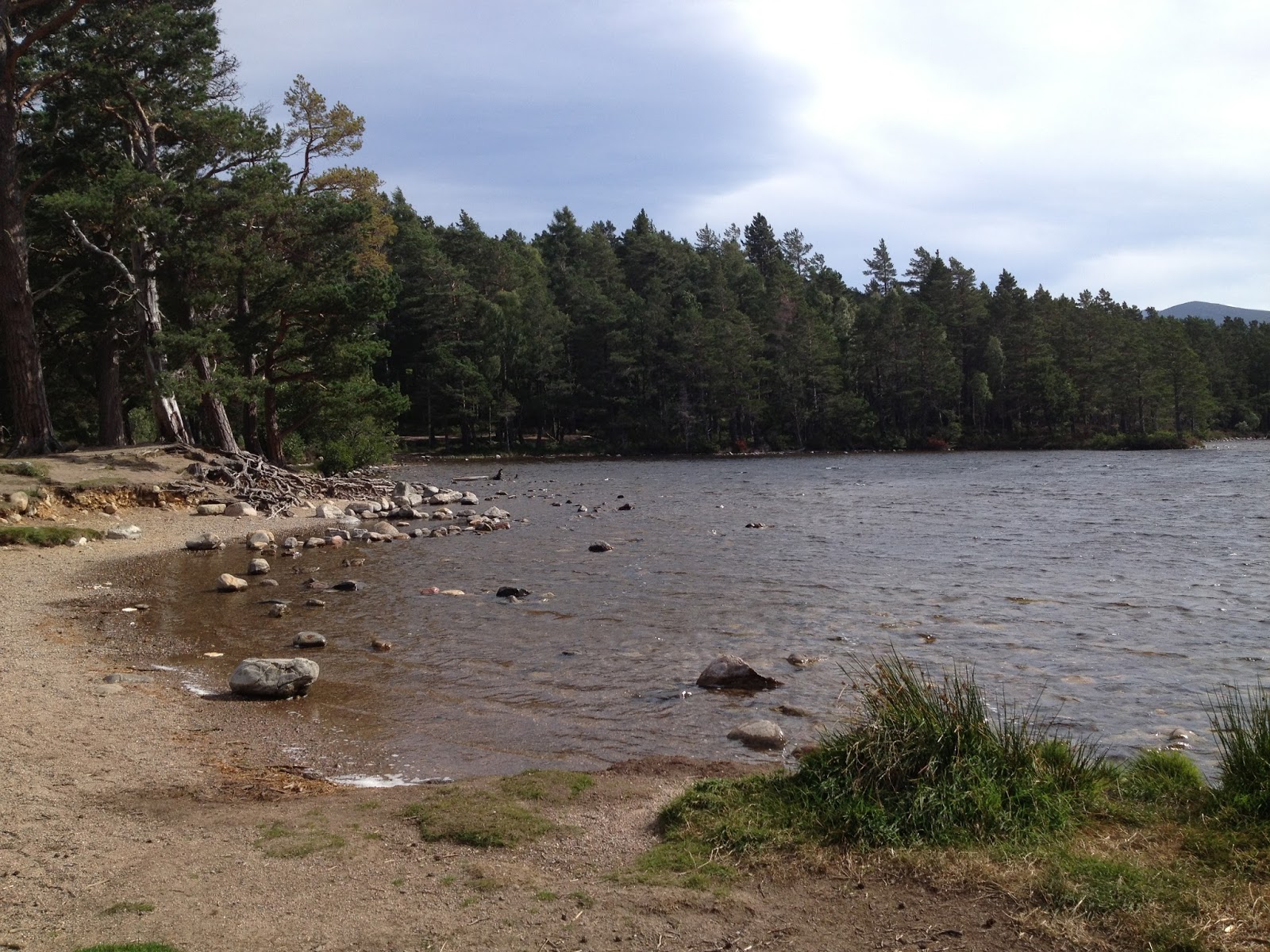
I was struggling a bit though, plodding uphill on this track, knowing I was close to the end of the day's walk, but not quite there yet. It seemed to take ages, but eventually I spotted the beach at the end of Loch Laggan, the largest expanse of freshwater beach in Britain.
I was now back to familiar territory, and continued alongside the road to Pattack Falls. Not for the faint-hearted - it will be fantastic when the plans for a new path to the falls, avoiding the road, are complete!
When I reached Pattack Falls the memories of my days as a Rabbies guide came flooding back. I stopped here as often as I could on tour, and it was always a favourite.

By chance, I'd timed it so well I spotted a Rabbies bus in the carpark! Then I spotted a pair of yellow trousers disappearing into the trees, and I knew it could only be one man.
Ally P - Legend!

This was a fantastic end to a long, tough day. My spirits were high indeed, and the only way was up. I spent the night at the Rumblie Guest House in Laggan and was blown away by the comfort and hospitality provided by Simon and Fiona. A challenging day, but with a wonderful ending!
 |
| red squirrel outside the Rumblie! |

Day Four: Feagour to Newtonmore - 14 miles
The problem with having such a comfortable bed is that it is so hard to get out of! I dragged myself out, knowing I had an interesting day ahead. I thought it would be quite straightforward, with the exception of the navigation towards Glen Banchor, and the river crossings.
On the drive back to Feagour I saw the most amazing rainbow, a sign of good things to come!

My day started with a way-marked forestry trail, and I decided to detour to the top of Black Craig hill to see the Pictish fort. The sun was beating down and now I was struggling in the heat! I zipped the end bits of my walking trousers off, and walked in shorts for the morning - this was exciting in itself!
Black Craig was a short sharp hill, and a bit of a push in the heat. It was well worth it though, Dun na-Lamh fort very impressive, and the views spectacular!

Back on the path I continued towards the Spey Dam, and then alongside the River Spey to Laggan. I walked through the village, before the next section of road walking on the A86. Thankfully the road is mostly straight here, so it is not quite as hair-raising as previous sections! After a mile or so the instructions were to take the road to Balgowan, a small settlement.
I saw the woods I was aiming for, and I knew the wilderness of Glen Banchor awaited me.
I stopped and prepared myself for what was ahead. This meant zipping my trousers back on (not as straightforward as I'd hoped!), putting my jacket on and taking a deep breath. And more jelly babies. It looked as though the weather was about to change, and I was aware that things could get quite bad in such an exposed area. As it turned out, it didn't actually rain once today, but I was ready for it anyway!
Stepping out from the woods, I identified the rowan tree my notes said to aim for.


From there I was to head for an estate track, although I could barely see it. I plodded through the heather, and eventually came to the track. I was relieved I had managed this section - and now I just had the troublesome river crossings to come!
The path swung round a corner into Strath an Eilich, and ahead of me was a stunning rainbow! In fact, almost a double rainbow! I couldn't keep the smile off my face, it was simply a beautiful moment.

I could see the estate path weaving its way down the glen, and all I had to do was follow it to a stalkers bothy. I was enjoying this, I was in the zone. Soon I spotted the bothy, headed for it, and hoped the river wasn't too high!
All of a sudden I spotted two guys sitting by the path, eating their lunch. They took me by surprise as I hadn't seen anyone for hours, and this was a random location to find anyone else! I assumed they were Munro-baggers, and had come off the hills. What was really strange was that they didn't look up - I thought they'd be as surprised to see me as I was to see them! I scuffed my feet on the path a bit more, hoping to catch their attention. Still nothing. As I was about to pass them, I went to nod hello and suddenly one of them turned their ginger-haired head slightly and I thought "he looks like my big brother".
The two guys stood up. I now know it was two of my brothers but at that moment I was dumbfounded! Even realising it was Colin and Andrew my brain just couldn't understand the fact that they were here, now! I was in the middle of nowhere, how and why were they here?!
When my slow brain finally realised they were here to see me (!!) I burst into tears! It was an amazing moment! I don't see either of them all that often, and Colin in particular lives in France. Having just got back from a 5 week trip to the States and about to return to France, I hadn't expected to see him until Christmas!


I joined them for lunch, and then we tackled the river crossings. They were a bit more difficult than I thought they'd be, but certainly passable, especially when you have some assistance!


Day Five: Newtonmore to Kincraig - 15.5 miles
My hips gave me a fair bit of trouble on this walk, probably due to the road walking and hard tracks. Each night I wondered whether I'd be fit enough to walk the next day. Each morning I woke up feeling better, but my hips still hurt. After a tough third and fourth day I felt pretty sapped by day 5. Looking at my mileage, I realised I had a long day ahead!
However, it was another good day! I had a bit of trouble getting out of Newtonmore, but once I was out into the open, the surrounding views were amazing. Another dry day, another day with the shorts on!
I felt lucky to be walking in August/September, as the bonny blooming purple heather was amazing! It really added to the whole thing for me, and made the views even better.

I traipsed through the heather, making my way to Loch Gynack. Really a beautiful spot!

Then I took the Golf Course Circular Path (great path!) towards Kingussie. As I ambled through the woods I disturbed two deer, my first of the walk. Quite a special moment so get so close.

When I reached the caravan park, I took advantage of the Gynack Mill Trail into Kingussie, which cut out some road walking, and is highly recommended.
I was into Kingussie and back out again rather quickly. I then walked under the A9 and up the hill to Ruthven Barracks - this was fantastic!

Here, with precision timing, I met Mum, Dad, Aunty Mary and Robbie, who were on their way to Hopeman. We had our picnic lunch at Ruthven Barracks, and enjoyed the blue skies and lovely views. I'd never been into the ruins before, so this was quite special.


The hardest part of the day was thinking I was close to Kincraig, and still having further and further to go. It was so hot in the sunshine, and I was sore. The path took us closer to Loch Insh, then away again. I was just frustrated by this point, and wanted to get there.


Day Six - Kincraig to Aviemore - 10.5 miles
Somehow I'd made it to my final day on the East Highland Way! I was looking forward to today, it was a short, straightforward day and the end felt close!

It was another sunny, although windy, day. Leaving Kincraig I visited the Frank Bruce Sculpture Park - really an incredible place. I found it quite eerie on my own, although very impressive.


Through the heather and trees, surrounded by blue skies, this was a spectacular part of the route. A really great last day!


I decided to see what all the fuss was about, and enjoyed my picnic lunch by the loch! A tad windy, but otherwise delightful!


All of a sudden, I came out of the forest at Rothiemurchus, and the signs said one mile to go!
This had happened quicker than I thought I would, and it was downhill all the way! I arrived in Aviemore in blazing sunshine, and was met by Mum and Dad!
I couldn't comprehend it, but I'd just completed my second long-distance trail - the East Highland Way, 82 miles from Fort William to Aviemore!
There's no end marker either, although the route finishes at the southern end of the Speyside Way. We couldn't find a marker for this, so the information board became the end point!!


 |
| thanks for the fizz (again) mum and dad! |
Back in the office the next day, it almost felt like this had been a dream. However, hips don't lie, and mine told me I'd done 82 miles! I almost feel back to 'normal' now, but is has taken a few lazy days! I'm very disappointed to have missed out on the West Linton Three Peaks Challenge this year, but I know if I had entered I probably wouldn't have finished it - and we can't have that!!
I'm thrilled to have completed this route - I do highly recommend it but it's definitely not as straightforward as most of Scotland's way-marked, long distance trails. It was a great taste of navigation and map-reading, and I was really proud of myself for managing! I do think my next trail will be a way-marked one, whilst I keep building up my confidence, but the East Highland Way took me to some amazing parts of Scotland.
The purple heather, the blue skies, the waterfalls, the isolated paths, the emptiness, the peace and quiet, the solitude, the views, the lochs, the loneliness, the surprises, the sheep, the challenge, the river hopping, the hospitality, the unexpected. The feeling of achievement. The pride. The support. The recovery!
I enjoyed reading about your travels Helen! I'm doing the EHW in April and I'm thoroughly looking forward to it : ) This will be my first long distance trail in Scotland, so I'm doing as much research as I can and reading other people's blogs on what they went through!
ReplyDeleteI want to do the WHW too, but that will have to wait another time! So many routes to do! : )
Thank you Rebecca! Really glad you enjoyed reading it. What a fantastic trail you have picked for your first one - it really offers so much.
DeleteYou'll be hooked I promise! You'll love the West Highland Way too. I'm full of plans for my next trail, there are just so many it's hard to pick the next one! Perhaps the Speyside Way or the St Cuthbert's Way...!
Let me know if you have any questions, I'd be more than happy to help. Have a great time, savour every step!!
Wonderful to have this sort of personal account, with fears, moments of drudgery, pleasure and satisfaction all recorded. Looking forward to having a go at it September 2017! David B.
ReplyDeleteHi David, sorry I didn't see your comment until now! I'm glad you enjoyed the blog...I kept a journal after each day of walking so I could remember all the various highs and lows. I'm glad I did because after a few years it's lovely to revisit and bring back all those memories again.
DeleteHow was your walk? I really hope you enjoyed it as much as I did!
Cheers, Helen
Hi Helen! Thank you so much for sharing - I loved reading your adventure. I'm thinking of doing the EHW solo in March (I'm also a female traveller). I'm wondering if you wild camped most nights or if you booked lodgings for all the nights? Alina xx
ReplyDeleteHi Alina!
DeleteThanks so much for your comment. I'm really glad you enjoyed the blog and are planning your own EHW adventure - you'll love it!
I am unfortunately not brave enough to wild camp so I did have accommodation booked for my trip, as follows:
Fort William: Corrie Duff Guest House (not sure it is still operating?)
Spean Bridge: The Braes for two nights (again not sure it is still open sadly)
Laggan: Rumblie Guest House
Newtonmore: Coig na Shee Guest House (one of the nicest places I've ever stayed in and highly recommended!)
Kincraig: Braeriach Guest House (there are limited options here, unfortunately I can't say I'd recommend this place)
Didn't stay in Aviemore as I travelled back to Edinburgh that same day but there's plenty of choice here.
Hope that's helpful, but let me know if you have any questions at all, and best of luck. I imagine things have changed quite a bit since I walked the trail 4.5 years ago!
Helen x